
This write-up is much longer than my previous efforts. If you want to skip past it, the photo section is below.
For our first backcountry trip in Idaho, we chose the central part of the Idaho Backcountry Discovery Route (ID-BDR). The Backcountry Discovery Routes organization creates off-highway routes for adventure and dual-sport motorcycle travel. Routes have been created for most of the western states and typically run from the state’s southern border to its northern. While the trails were mapped for motorcycles, most are also suitable for 4-wheel drive vehicles. While we had the trip all mapped out we had to be ready to quickly reroute as it is wildfire season.
We started the ID-BDR in Glenns Ferry, ID and took it as far as Darby, MT. On August 14 we all met up in Glenns Ferry, Tucker & Ben from California, Mark & Cliff from Idaho, Don from Oregon and Vince from Wyoming. After topping our gas tanks, we headed north through volcanic tablelands to reach Anderson Lake on the Boise River. Leaving Glenns Ferry, discovered my Garmin GPS lost all the trip waypoints, so a few stops to check our paper maps and the group’s mapping apps were required to find our way. [after the photos there is a tech note on the Garmin issue and how it was fixed the second night out]
When we reached Fall Creek, half way up Anderson Lake, the ID-BDR turned right towards the town of Pine, while the road sign said that Trinity Lakes (where we were headed) was straight ahead; so we took our first detour of the trip by going straight, which turned out to be a harder road, getting to the lakes from the south. We did get some great views on the way up to the 8500ft pass below the Trinity Lookout. Arriving at the Big Trinity Lake campground we set up camp for the night, elevation 7800 ft. After dark a Forest Ranger came by on an ATV. He was investigating the theft of antique equipment from the Trinity Lookout that had happened a day or so before, when the staff was off for a few days. Said he also has to hide his Forest Service pickup that carries the ATV, lest it gets spray painted or tires slashed. Not things you want to think about when you are out enjoying the great outdoors.
Mark, Don, Ben and Cliff have outfitted their vehicles so they can sleep inside. Tucker has a rooftop tent he uses and Vince tent camps.
Heading north the next morning, August 15, from Trinity Lakes, we rejoined the ID-BDR until we reached the Middle Fork of the Boise River, where we made a side trip to the old mining town of Atlanta. On the way, we saw an osprey and its nest. The town has many old buildings, about 20 residents and two good campgrounds. Returning from the side trip we continued north on the ID-BDR. About 40 miles before reaching the town of Lowman, we found the road barricaded due to washouts. This second trip detour took us out to paved highway 21 and on to Lowman. After finding gas in Lowman we headed north on the ID-BDR, and after just 16 miles we encountered our third detour. Where the ID-BDR turns west to Deadwood Lake: the road was closed due to a fire in that area. From that junction we were able to continue north until we reached a road heading west that was open.
After that 23 mile detour, we rejoined the ID-BDR well above Deadwood Lake. (Our plan had been to camp at the Deadwood Lake campground.) By now the sun had set and we were looking for a new place to camp, but there were no campgrounds along this section of the ID-BDR. One of the short side roads we checked, had been set up with bait for bears, using several hundred eggs and some beef bones, guessing by hunters. We waved at the game camera and got out of there — not our idea of a place to camp. Ben has wanted to see a bear, but that would not have been a good encounter. After checking several sites, we found a nice clearing along the Deadwood River, elevation 5700ft. An old travel trailer was parked there but was not in use, though probably would be occupied later in the year when hunting season starts.
The next morning, August 16, Vince set up his new portable shower, water heater and pump to use water out of the creek. Had happy campers after their hot showers. Vince spends a lot of time camping, and he surprises us every trip with great gear he has squirreled away in his Cruiser. On our drive up to Yellow Pine, we saw Sandhill Cranes and Pronghorn Antelopes in some of the meadows. Further along while looking for a side road to an old mine, we came across some foxes.
The town of Yellow Pine had been without power for 5 days due to a fire in the area, so many residents had tables and canopies set up in the street to visit with their neighbors. Some of us needed gas and fortunately they had a generator to power the gas pump at the station. It was fun visiting with the town’s folks that live so remotely. I got into a discussion with a feisty lady about the Forest Service; seems the federal edict to close backcountry roads did not go over well. She said that that action left a number of small towns with only one route to escape forest fires, and if the fire was coming along that road, there was no way out. The rest of the day on the ID-BDR was filled with a number of long climbs and descents with many switchbacks: over 8500ft passes and down to below 3000ft at the bottom of canyons — similar to what it would be like to drive to the bottom of the Grand Canyon. Some of the terrain was so steep you wondered how the forest grew on the slopes. We had had enough and decided to skip the last set of ups and downs on the ID-BDR to Hwy 14, leaving the ID-BDR to get gas in Riggins. Then we backtracked a few miles up the Salmon River to a camp area we had seen on the way into town, elevation 1770ft. While all of us except Vince had been sleeping in our vehicles. Cliff broke out his tent this night due to it being warmer at this elevation. The Salmon River is called the “River of No Return”. Its swift current and large rapids make upstream travel difficult, hence the name. We crossed the Salmon River many times as it winds it way through the mountainous territory, both going north on the ID-BDR and when we came south on US-93.
The next morning, August 17, we crossed the Time Zone Bridge just north of Riggins. Idaho has two time zones, most of the state is in Mountain while the northern panhandle is in Pacific. So we were now in the Pacific until entering Montana. We continued up US-95 to Grangeville (detour number four) and then Hwy 14 to Elk City, the ID-BDR joins Hwy 14 about 17 miles after Grangeville. 15 miles southeast of Elk City we reached the start of the Magruder Corridor portion of the ID-BDR. Our first stop on the Magruder was for making our lunch at the Green Mountain Lookout, which was up a steep side road having grand views. Then it was off to see the next lookout. The side road to Burnt Knob Lookout was badly washed out, exposing large rocks. Three of our group started up the road to determine the state of the road; they worked their way up about a half mile. We decide getting all six of us clear up to the lookout and back would take more time than we had, so the three picked their way back down. Continuing on the ID-BDR, we could see quite a bit of smoke in the distance to the south as we drove. When we reached the Selway River, it was time to find a camp, so we turn up the road along the Selway looking for campsites. Cliff’s Cruiser was in the lead when a black/brown bear came out of the river and ran up the road in front of him for a couple of hundred feet. Really bummed to not get a photo as it ran off the road into thick brush and disappeared. At the end of the road, we found the Paradise Campground and set up camp, elevation 3100ft.
The next morning, August 18, we headed for the turnoff for Hells Half Acre Lookout. Along the way we saw the forest in many stages from burnt with no trees, to young trees, to mature trees. Once reaching the turnoff, it was a good climb to the lookout. As we approached the top, we encountered burnt trees that had blown down across the road. Some we could drive over, others could be manhandled out of the way, and a couple required a chainsaw. Of course, Vince had a chainsaw with him. At the Hells Half Acre Lookout, the lady staffing it was a volunteer. She is a school teacher in Montana who does lookout work during her summer vacations. Said she enjoys the solitude of lookouts — probably a good change to get away from the students. Then it was back out to the ID-BDR and on to Darby, MT as Cliff’s cousin has a cabin there, where we could shower and spend the night. We went in to Darby for dinner (first meal out of the trip) and passed by the ranch they use for the TV series “Yellowstone”.
The ID-BDR continues north from Darby to Lolo, MT and then cuts back into Idaho on its way to the Idaho/Canada border. We are saving that section for a future trip.
The next morning, August 19, Vince left, as he decided to head home across Montana. Heading south from Darby we left the ID-BDR behind and traveled a section of the Lewis and Clark Trail as US 93 follows it as far south as Salmon. Sacagawea, their guide, was born near Salmon. Tucker split off from us a ways down US 93, to travel faster as he needed to arrive home the next day. Mark, Ben, Don and Cliff continued south on US 93 to Challis where they turned west onto backcountry roads. Next stop was the mining ghost town of Custer, followed by the Yankee Fork Gold Dredge. We arrived at the dredge early enough to take the tour. The dredge is one of the few complete ones you can tour, and it was great to see how they work. Link to Dredge specifications
As we came out of the dredge we saw heavy smoke to the west. Our plan had been for us to camp in the area, because we had expected to tour the dredge the next day. To be safe, we decided to drive to cell coverage to determine the fire situation. It turned out we couldn’t get coverage until Stanley, and once there we could see it was a major fire, the Wapiti Fire. After some debate, we decided to continue driving to Cliff’s home near Twin Falls. Guess you could call it detour number five, finishing the trip a day early.
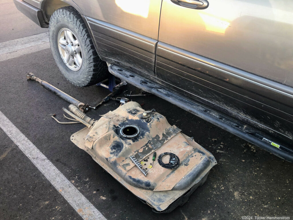
Tucker’s adventures were not over however. He had traveled to around Wells, NV when his Cruiser died. Was able to eventually get it started and in to Elko. Once there it would not restart. Turned out to be the fuel pump, luckily he was carrying a spare. With the truck having a full drawer system and loaded, getting to the fuel tank access panel in the floor would be a major project. So with the help and extra tools of a mobile mechanic service they dropped the full fuel tank, a slightly less major project, and replaced the fuel pump in it.
| Photo Contributions: | Ben D | 11 photos |
| Tucker H | 5 photos | |
| Susan | 2 photos |
Garmin Tech Note
Before the trip I had downloaded all the waypoints for this trip from Basecamp on my computer to the Garmin GPS like I have done for many previous trips. From Basecamp I could see the waypoints were in the GPS and had not received an error message. Since it had always worked I didn’t check on the GPS that they were in Saved locations as I still had lots of free memory in the GPS. So it was a surprise when I couldn’t find any of the trip waypoints at start of the trip. The second day out I went to save a location in the GPS of a special spot and got something like a memory full message. So that night at camp I erased all the Saved locations. Then downloaded all the trip waypoints from my laptop and there they were, problem solved. Turns out the model Garmin I have has a limit of 1000 Saved locations. But for two days we were using backup methods to navigate. It is always important to carry many ways to navigate. I have had GPSs die on trips before, so try to not be totally dependent on them. So while they were somewhere in the GPS’s memory they were not added to Saved locations. In the future I may convert those waypoints into a POI file which is only limited by the GPS’s memory.